Posts

What is Lima

Image
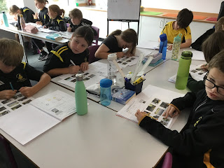
  During the lesson, the children identified where Peru is and its capital city: Lima.  They had to guess how many times bigger Peru was than Great Britain. Do you know? Peru is actually four times bigger than Great Britain but has half the population. Why you ask? The land is mainly desert, the Andes are to the East and the coast is to the west.  They were then given 6 photos of Lima to discuss and compare - 3 were from urban Lima and 3 from rural Lima. The children were shocked how the people in rural Lima had to live without any clean water. Did you know Lima is permanently in fog. People who live there need to grow their own food but in order to do this they need water. Ingeniously, they have designed fog nets which trap the water from the fog. Each net can collect 400ml of water,: enough to water some of the ground. However, it cannot be drunk so they need to buy their drinking water.  The final part of the lesson, asked children to evaluate if it was fair for children who live in

Year 3 - WB 15.01.24

Image
 We have had a very busy week in Year 3, in Maths we have been multiplying 2-Digit numbers and dividing. In English we have been writing an ending to the story we have been exploring called ‘Flood’ and in Art we have been painting some beautiful Fossils using watercolours. A busy but fantastic week Year 3 well done :) 

What makes up South America?

Image
The first part of the lesson the children used an atlas to help them explain where South America is located. The children really thought about this and they shared their responses with the class.  Then, the children identified the 12 sovereign states of South America and the 2 non- sovereign states: Falkland Islands and French Guiana. Finally they identified where the capital cities are found and why Bolivia has two capital cities. 

South America

Image
 This term the children will be studying South America. Here is a copy of their journey.  During the first part of the lesson, the children recapped the different lines of latitude and longitude they have learnt throughout key stage 2. Then, they compared four different types of maps about South America: relief maps, political maps, tectonic plate maps and language maps.  Finally, the children used their knowledge of longitude and latitude as well as understanding that there is 15 degrees between each line of latitude on a map. Once this was understood, the children identified the latitude and longitude for different places on the world map. 

Assessment

Image
 This week, the children were given a question to answer’ How are natural disasters caused and what effect do they have?  There were some great discussions in the classrooms and everybody was able to discuss how the Tectonic Plates move and how this causes natural disasters, 

French: lesson 4: writing a paragraph

Image
 Year 6 revised school vocabulary and the use of voici. They then learnt the difference between le/la and un/une, and changed words from the to a which they then used to write a paragraph about their school. 

French: lesson 3: using voici with school vocabulary

Image
 Year 6 learnt the names of different areas found in a school. They listened to a video of a little boy in Martinique showing them around  his school. We discussed the differences between his school and ours. They then labelled pictures using Voici.