Posts

Showing posts from September, 2023

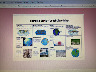
What are the Earth’s layers?

Image
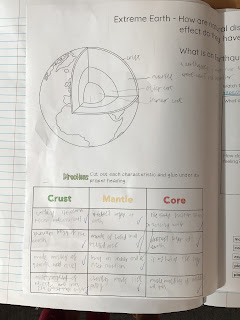
 This week the children identified the different layers of the Earth and what they are made of. They watched a clip so they could visually a representation of the inner and outer core. Then, they watched a short clip of the earthquake in Turkey to see how land and properties actually move from the vibrations and the devastating effects earthquakes have on both human and physical geography. Finally, the children reflected on how other children and people in the world suffer and need support from other countries. 

Design Technology w.b 2nd October Year 6

Image
 

Homework week 3 due 6th October

Image
  Please note : page 14 states B.O.D.M.A.S but the children will know this as B.I.D.M.A.S

Handball - Year 6

Image
 Both classes enjoyed great lessons putting into practise all the skills we have been working on for the last three weeks. It was fantastic to see such great teamwork, communication and co-orientation. 

Our young leaders for 22/23

Image
 

Welcome to Year 6 slides

Here are our slides from the Welcome to Year 6. Please pause the video where appropriate to read each slide. Please note slide slide 17, where we state SATS week is WB: 13.5.23.  Any more questions please feel free to message year6@gurnardprimaryschool.co.uk  Mr Lines and Mr Clark 

What is an Earthquake and how does it occur?

Image
This week and next week’s lesson allows the children to identify and discuss how the Earth is formed and how these formations can cause earthquakes.  Today, they looked at the tectonic plates that cover the Earth and three different ways they move: divergent, convergent and transform. They then identified the effects these movements have on the Earth.  From there, they looked at how seismic waves travel through the Earth and how they are measured.  Finally, they looked at the charity: Shelterbox. This charity supports people who have been affected by earthquakes and provides them with the necessary equipment to survive. The children then decided what items they would need to survive. 

I can describe how human and physical geography can have an impact on climate change.

Image
 This week the children started as usual by answering their ‘sticky knowledge’ questions from the previous week, discussing how lines of latitude dictate the climate in different countries.  They then studied climate graphs, where the red line represented the temperature and the blue bars  represented the precipitations. From here they matched up statements, pictures and the graphs of different climate zones.  The next part of the lesson looked at how both human and physical geography are contributing to climate change. The children then drew around their foot (their carbon footprint) and identified everything they had used that day that could have contributed to climate change. 

PE for WB: 10.9.23

Image
This week the children in Year 6 have been learning all about attacking and defending space in

I can identify the different climate zones in the world and how the lines of latitude are linked to climate.

Image
 Our new topic this term is Extreme Earth. The children were introduced to their new vocabulary as well as their journey.  They then recapped the different lines of latitude and longitude as well as the hemispheres. A quick reminder about the difference between climate and weather took place as well as identifying the different climate zones.  From there, the children used an atlas to work out which climate zones countries could be found and why.