Finally! Year 6 were pleased to hear that they can now start putting their research together to write their fact files about Everest. Being focussed and keen, they worked hard to start putting their information together using a range of powerful and descriptive sentences. Here are a few pictures of us starting our files.
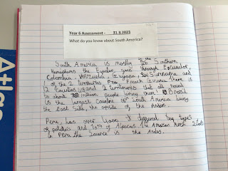
Our last session about South America and the children did themselves proud using all their knowledge and skills to describe what they knew aboutSouth America. Well done year 6, enjoy. Your Easter break.
This term the children will be studying South America. Here is a copy of their journey. During the first part of the lesson, the children recapped the different lines of latitude and longitude they have learnt throughout key stage 2. Then, they compared four different types of maps about South America: relief maps, political maps, tectonic plate maps and language maps. Finally, the children used their knowledge of longitude and latitude as well as understanding that there is 15 degrees between each line of latitude on a map. Once this was understood, the children identified the latitude and longitude for different places on the world map.


Comments
Post a Comment